
Changes in appearance and in display of formulas, tables, and text may have occurred during translation of this document into an electronic medium. This HTML document may not be an accurate version of the official document and should not be relied on.
For an official paper copy, contact the Florida Public Service Commission at contact@psc.state.fl.us or call (850) 413-6770. There may be a charge for the copy.
State of Florida
Public Service Commission
Capital Circle Office Center 2540 Shumard Oak Boulevard
Tallahassee, Florida 32399-0850
- M-E-M-O-R-A-N-D-U-M-
|
DATE: |
||
|
TO: |
Director, Division of the Commission Clerk & Administrative Services (Bayó) |
|
|
FROM: |
Division of Economic Regulation (Redemann) Office of the General Counsel (Brubaker) |
|
|
RE: |
||
|
AGENDA: |
08/15/06 – Regular Agenda – Interested Persons May Participate |
|
|
COMMISSIONERS ASSIGNED: |
||
|
PREHEARING OFFICER: |
||
|
SPECIAL INSTRUCTIONS: |
||
|
FILE NAME AND LOCATION: |
||
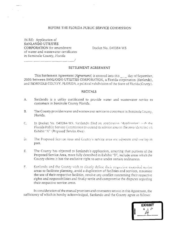
On April 30, 2004, Sanlando Utilities Corporation (Sanlando or utility) filed an application with the Commission to amend Water Certificate No. 247-W and Wastewater Certificate No. 189-S, in order to include areas that were inadvertently not included in the existing water and wastewater service areas. Sanlando provides water service to approximately 10,034 water and 8,201 wastewater customers in Seminole County. The utility is located in the St. Johns River Water Management District, and Seminole County is in a priority water resource caution area. Several customers wrote letters objecting to Sanlando’s application; however, none of these customers elected to pursue their objections at hearing. Seminole County filed a protest to the application on May 24, 2004, but on November 1, 2005, Sanlando filed a motion for approval of a settlement agreement between Sanlando and Seminole County, which would resolve Seminole County’s objection to Sanlando’s amendment application. The City of Longwood filed a protest to the application on May 10, 2004, and by Order No. PSC-05-1001-PCO-WS, issued October 17, 2005, this matter was scheduled for an administrative hearing. However, on June 2, 2006, the City of Longwood withdrew its objection, and the hearing was accordingly cancelled. The Commission has jurisdiction pursuant to Section 367.045, Florida Statutes.
Issue 1:
Should Sanlando Utilities Corporation be ordered to show cause, in writing, within 21 days, why it should not be fined for serving outside its certificated territory without prior Commission approval in apparent violation of Section 367.045(2), Florida Statutes?
Recommendation: No. The Commission should not order Sanlando Utilities Corporation to show cause for failing to obtain an amended certificate of authorization prior to serving outside of its certificated territory.
(Brubaker, Redemann)
Staff Analysis:
Sanlando’s June 29, 2004, amendment to its application states that, in the process of reviewing its certificated service areas for a 2003 docket, Sanlando discovered that it has been providing service to areas that were inadvertently not included in its current certificated territory. Sanlando filed its application to consolidate and correct the inconsistencies in Sanlando’s territorial legal description, and to include those areas to which the utility has been providing service, but which were not within Sanlando’s current legal description. Sanlando has been serving the area for over 30 years; however, when Utilities, Inc. purchased Sanlando in 1998, it did not perform a review of the service territory. The current owners of Sanlando have been providing water and wastewater service to customers in the proposed extension area since approximately 1998, and will continue to do so without any changes in connections, interruption, or curtailment of service.
Sanlando has been serving water customers outside of its certificated territory, in apparent violation of Section 367.045(2), Florida Statutes. That section states that a utility may not extend its service outside the area described in its certificate of authorization until it has obtained an amended certificate of authorization from the Commission.
Section 367.161(1), Florida Statutes, authorizes the Commission to assess a penalty of not more than $5,000 for each offense, if a utility is found to have knowingly refused to comply with, or to have willfully violated any provision of Chapter 367, Florida Statutes. In serving outside of its certificated territory without obtaining an amended certificate of authorization, the utility’s act was “willful” in the sense intended by Section 367.161, Florida Statutes. In Order No. 24306, issued April 1, 1991, in Docket No. 890216-TL, In Re: Investigation Into The Proper Application of Rule 25-14.003, Florida Administrative Code, Relating to Tax Savings Refund For 1988 and 1989 For GTE Florida, Inc., having found that the company had not intended to violate the rule, the Commission nevertheless found it appropriate to order the utility to show cause why it should not be fined, stating that “[i]n our view, ‘willful’ implies an intent to do an act, and this is distinct from an intent to violate a statute or rule.”
Although Sanlando’s failure to obtain Commission approval prior to serving outside of its certificated service area is an apparent violation of Section 367.045(2), Florida Statutes, there are circumstances which appear to mitigate the utility’s apparent violation. The customers Sanlando are serving outside of its territory are located adjacent to Sanlando’s certificated service area. When the customers were connected, Sanlando believed they were within its service area due to their location. Believing that the customers were located within its service area, Sanlando has paid all the necessary regulatory assessment fees for the additional area. Furthermore, upon becoming aware that the customers were not located within its certificated territory, Sanlando filed an application for amendment of its certificate to include the additional area.
Staff does not believe that the apparent violation of Section 367.045, Florida Statutes, rises in these circumstances to the level which warrants the initiation of a show cause proceeding. Therefore, staff recommends that the Commission not order Sanlando Utilities Corporation to show cause for failing to obtain an amended certificate of authorization prior to serving outside of its certificated territory.
Issue 2:
Should Sanlando’s Motion to Approve the Settlement Agreement between Sanlando and Seminole County be granted?
Recommendation:
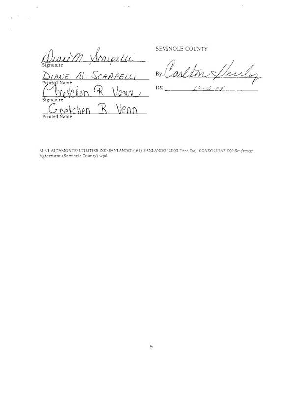
Yes. Sanlando’s motion should be granted and the Settlement Agreement between Sanlando and Seminole County should be acknowledged. (Brubaker, Redemann)
Staff Analysis:
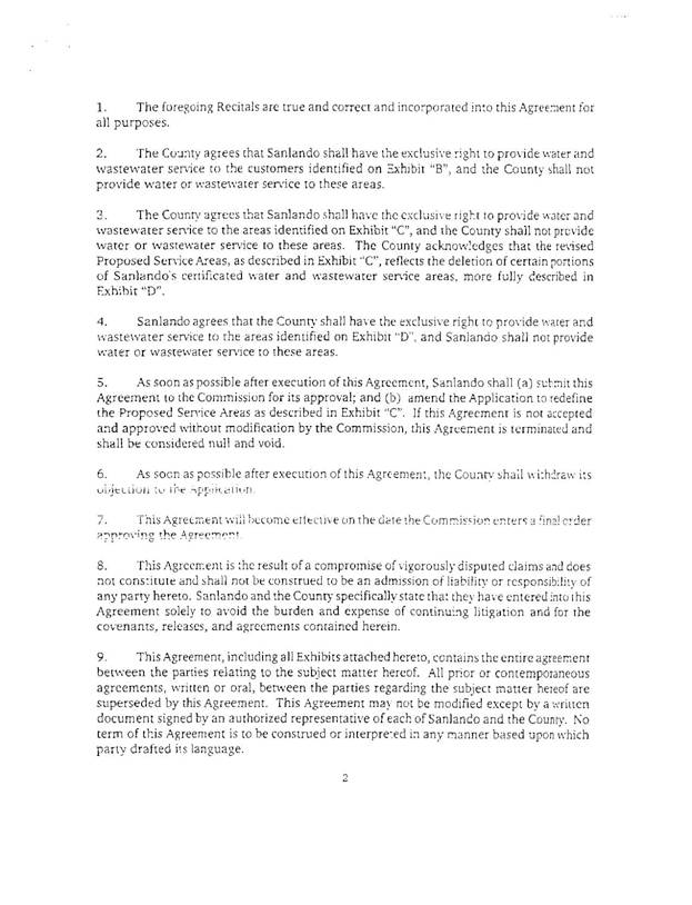
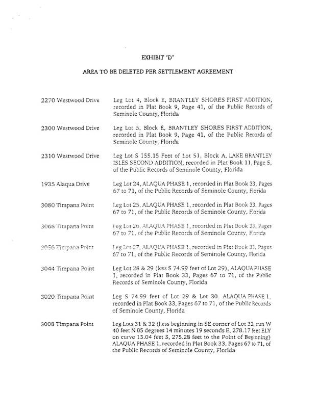
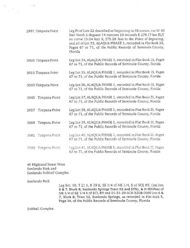
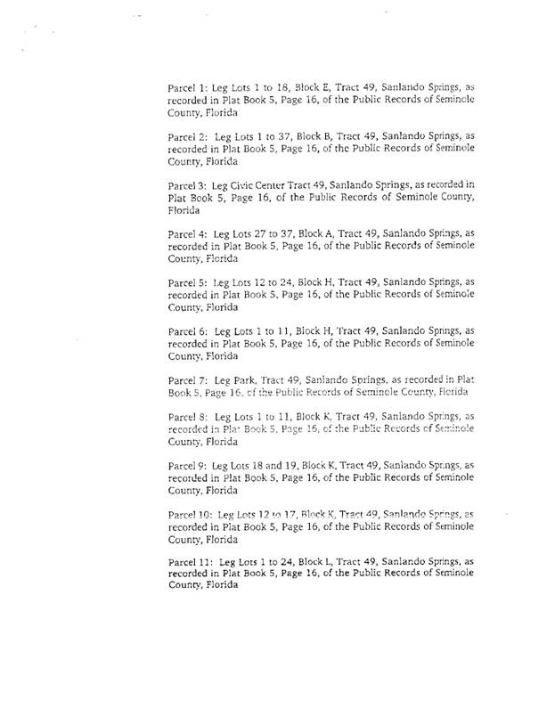
As mentioned in the Case Background, Seminole County filed for approval of a proposed Settlement Agreement entered in September 2005 (see Attachment A). The agreement provides that Seminole County and Sanlando agree that each shall have exclusive rights to provide service to specific areas as set forth in the agreement, and that Sanlando will delete certain water and wastewater areas from its already certificated area.
Due to the Settlement Agreement, the utility renoticed to modify its territory to show in part a deletion, and part an addition to reflect the terms of the Settlement Agreement. No objections to the modified territory description were received, and the time for filing such has expired.
Staff believes that the proposed Settlement Agreement is a reasonable solution to resolve the territory dispute between Sanlando and Seminole County. Based on the above, staff believes that the approval of the proposed Settlement Agreement is in the public interest and Sanlando’s motion to approve the Settlement Agreement should be approved.
Issue 3:
Should the Commission approve the application to amend Certificates 247-W and 189-S in Seminole County by Sanlando Utilities Corporation?
Recommendation:
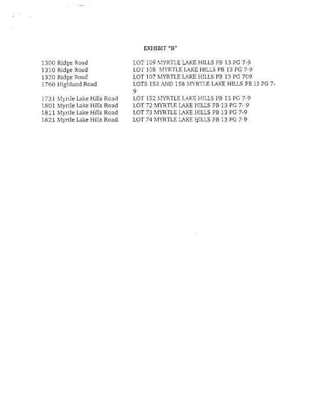
Yes, the Commission should approve Sanlando Utilities Corporation’s amendment application. The proposed territory and the deleted territory are described in Attachment B, and the utility’s composite description is described in Attachment C. The utility should charge the customers in the territory added herein the rates and charges contained in its current tariff until authorized to change by the Commission. (Redemann)
Staff Analysis:
On April 30, 2004, Sanlando filed an application for amendment of its certificates. The application is in compliance with the governing statute, Section 367.045, Florida Statutes, and other pertinent statutes and administrative rules concerning an application for amendment of certificate.
Adequate service territory and system maps and a territory description have been provided as prescribed by Rule 25-30.036(3) (e), (f) and (i), Florida Administrative Code. A description of the proposed territory and the deleted territory relative to the Settlement Agreement (collectively, the new territory) is appended to this recommendation as Attachment B. A composite description including all previously granted territory and the new territory is appended to this recommendation as Attachment C.
In addition, the application contains proof of compliance with the noticing provisions set forth in Rule 25-30.030, Florida Administrative Code. As mentioned earlier, Seminole County filed a protest to the application on May 24, 2004, but an agreement was reached with Seminole County (Issue 2). In addition, the City of Longwood filed a protest to that application on May 10, 2004, but withdrew its protest on June 2, 2004. The Department of Community Affairs (DCA) has identified no growth management concerns with the proposed expansion of the utility. The utility states that the provision of service will be consistent with the utility section of the local comprehensive plan. The utility has submitted an affidavit consistent with Section 367.045(2)(d), Florida Statutes, that it has tariffs and annual reports on file with the Commission.
Sanlando has three integrated water treatment systems: the Overstreet, the Des Pinar, and the Wekiva water treatment systems, with a design capacity of 17.925 million gallons per day (mgd). The max day within the past twelve months was 15.129 mgd. Sanlando has two separate wastewater treatment systems. The Des Pinar wastewater treatment system with a design capacity of .5 mgd on an annual average daily basis (AADF), and the Wekiva wastewater treatment system with a design capacity of 2.9 mgd on an AADF. The average daily flow for the Des Pinar plant over the 12 previous months was 0.353 mgd. The average daily flow for the Wekiva plant over the previous 12 months was 2.320 mgd.
Sanlando has been providing service continuously to customers in the extension area since it acquired the systems in 1998, and thus demonstrated sufficient capacity to serve them. The utility indicates that it has sufficient capacity to serve an additional 2,500 customers. Therefore, there will be no impact on the capacity of the systems. Staff has contacted the Department of Environmental Protection (DEP) and learned that there are no outstanding notices of violation issued for the systems. The utility utilizes licensed operators to operate the systems.
Regarding the financial impact of these customers to the utility, the customers are already connected to Sanlando. The application states that this extension area will not have any impact on Sanlando’s rates or service availability charges. Consequently, staff believes that Sanlando has demonstrated the financial and technical ability to provide quality service to these customers. The utility has filed revised tariff sheets incorporating the addition and deletion of territory into its tariff and returned its certificates for entry reflecting the addition and deletion of territory.
Based on the above, staff recommends that the Commission should approve Sanlando Utilities Corporation’s amendment application. The proposed territory and the deleted territory are described in Attachment B, and the utility’s composite description is described in Attachment C. The utility should charge the customers in the territory added herein the rates and charges contained in its current tariff until authorized to change by the Commission.
Issue 4:
Should this docket be closed?
Recommendation:
Yes. If the Commission votes to approve staff’s recommendations in the previous issues, this docket should be closed. (Brubaker)
Staff Analysis:
Yes. If the Commission votes to approve staff’s recommendations in the previous issues, this docket should be closed.
NAME OF COMPANY Sanlando Utilities Corporation
DESCRIPTION OF TERRITORY SERVED
Water Service Area
Seminole County
ADDITIONS TO WATER SERVICE AREA
That portion of Section 2, Township 21 South, Range 29 East, Seminole County, Florida being more particularly described as follows:
Begin at a point at the Northwest corner of said Section 2, and the POINT OF BEGINNING, thence South for a distance of 3700 feet; thence North 55º East for a distance of 2500 feet; thence North for a distance of 850 feet; thence North 27º East for a distance of 1650 feet; thence West 2800 feet to the POINT OF BEGINNING;
AND, That portion of Section 4, Township 21 South, Range 29 East, Seminole County, Florida, being more particularly described as follows:
Begin at a point at the Northeast corner of said Section 4 and the POINT OF BEGINNING; thence West for a distance of 1350 feet; thence South 40º East for a distance of 1900 feet; thence North for a distance of 1500 feet to the POINT OF BEGINNING;
AND, That portion of Section 4, Township 21 South, Range 29 East and Section 33, Township 20 South, Range 29 East, Seminole County, Florida, being more particularly described as follows:
Commence at the Northwest corner of said Section 4; thence East 2950 feet to the POINT OF BEGINNING; thence North 1100 feet; thence South 45º East along the South Right-of-Way of Wekiva Springs Road 250 feet; thence South 2200 feet; thence West 500 feet; thence North 500 feet; thence North 30º East 600 feet; thence North 250 feet to the POINT OF BEGINNING;
AND, That portion of Section 7, Township 21 South, Range 29 East, Seminole County, Florida, being more particularly described as follows:
Commence at the Northeast corner of said Section 7; thence South 1320 feet to the POINT OF BEGINNING; thence South 1320 feet; thence West 1320 feet; thence North 660 feet; thence East 660 feet, thence North 660 feet, thence East 660 feet to the POINT OF BEGINNING;
AND, That portion of Section 7, Township 21 South, Range 29 East, Seminole County, Florida, being more particularly described as follows:
Commence at the Northeast corner of said Section 7; thence South 4320 feet to the POINT OF BEGINNING; thence continue South 400 feet; thence West 250 feet; thence North 400 feet; thence East 250 feet to the POINT OF BEGINNING;
AND, That portion of Section 7, Township 21 South, Range 29 East, Seminole County, Florida, being more particularly described as follows:
Commence at the Southeast corner of said Section 7; thence North 150 feet to the POINT OF BEGINNING; thence West 150 feet; thence North 200 feet; thence West 100 feet; thence North 150 feet; thence East 250 feet; thence South 350 feet to the POINT OF BEGINNING;
AND, That portion of Section 29 & 30, Township 20 South, Range 29 East, Seminole County, Florida, being more particularly described as follows:
Begin at the Southwest corner of said Section 30 and the POINT OF BEGINNING; thence North 550 feet; thence East 2750 feet; thence North 57º East 650 feet; thence East 400 feet; thence South 38º East 780 feet; thence North 67º East 2050 feet; thence South 36º East 600 feet; thence East 685 feet; thence North 68º East 425 feet; thence East 300 feet; thence South 360 feet; thence East 300 feet; thence North 72º East 610 feet; thence South 77º East 630 feet; thence South 65º East 570 feet; thence South 240 feet; thence West 9800 feet to the POINT OF BEGINNING;
AND, That portion of Section 14, Township 20 South, Range 29 East, Seminole County, Florida, being more particularly described as follows:
Commence at the Southwest corner of said Section 14; thence East 1320 feet to the POINT OF BEGINNING; thence North 330 feet; thence East 1320 feet; thence South 330 feet; thence West 1320 feet to the POINT OF BEGINNING;
AND, That portion of Section 22 & 27, Township 20 South, Range 29 East, Seminole County, Florida, being more particularly described as follows:
Begin at the Southeast corner of said Section 27 and the POINT OF BEGINNING; thence West 1960 feet; thence North 3560 feet; thence North 05º East 880 feet; thence North 45º East 620 feet; thence North 11º East 400 feet; thence East 410 feet; thence North 1200 feet; thence North 19º East 1975 feet; thence East 310 feet; thence South 8330 feet to the POINT OF BEGINNING;
AND, That portion of Section 25, Township 20 South, Range 29 East, Seminole County, Florida, being more particularly described as follows:
Begin at the Northeast corner of said Section 25; thence South 2300 feet; thence West 1900 feet; thence South 950 feet; thence West 600 feet; thence North 700 feet; thence East 250 feet; thence North 1320 feet; thence West 850 feet; thence South 850 feet; thence West 900 feet; thence South 17º West 750 feet along the Southeasterly Right-of-Way of Interstate-4; thence South 36º East 700 feet; thence South 500 feet; thence West 600 feet; thence North 1600 feet; thence North 17º East 1685 feet along the Northwesterly Right-of-Way of Interstate-4; thence North 73º West 300 feet; thence North 17º East 500 feet; thence South 73º East 300 feet; thence North 17º East 300 feet; thence East 2550 feet, thence South 500 feet, thence South 45̊ West 600 feet, thence West 160 feet, thence South 150 feet, thence East 140 feet, thence South 110 feet, thence West 150 feet, thence South 75 feet, thence West 123 feet, thence South 755 feet, thence East 275 feet, thence South 160 feet, thence West 350 feet, thence South 150 feet to the POINT OF BEGINNING.
AND, That portion of Section 25, Township 20 South, Range 29 East, Seminole County, Florida, being more particularly described as follows:
Commence at the Southwest corner of said Section 25; thence East 990 feet to the POINT OF BEGINNING; thence North 1320 feet; thence East 330 feet; thence South 1320 feet; thence West 330 feet to the POINT OF BEGINNING;
AND, That portion of Section 25, Township 20 South, Range 29 East, Seminole County, Florida, being more particularly described as follows:
Commence at the Southwest corner of said Section 25; thence East 1650 feet to the POINT OF BEGINNING; thence North 660 feet; thence East 330 feet; thence South 660 feet; thence West 330 feet to the POINT OF BEGINNING;
AND, That portion of Section 25, Township 20 South, Range 29 East, Seminole County, Florida, being more particularly described as follows:
Commence at the Southeast corner of said Section 25; thence West 1900 feet to the POINT OF BEGINNING; thence West 150 feet; thence North 660 feet; thence East 150 feet; thence South 660 feet to the POINT OF BEGINNING;
AND, That portion of Section 36, Township 20 South, Range 29 East, Seminole County, Florida, being more particularly described as follows:
Commence at the Southwest corner of said Section 36; thence East 600 feet to the POINT OF BEGINNING; thence North 2900 feet; thence East 2000 feet; thence North 2600 feet; thence East 200 feet; thence South 660 feet; thence East 330 feet; thence South 550 feet; thence East 400 feet; thence South 500 feet; thence East 900 feet; thence South 2300 feet; thence West 1500 feet; thence South 1400 feet; thence West 2300 feet to the POINT OF BEGINNING.
Water Service Area – AREAS TO BE DELETED FROM APPLICATION
That portion of Section 23, Township 20S, Range 29E, Seminole County, Florida, being more particularly described as follows:
The Northwest ¼ of the Northwest ¼ of said Section 23.
AND, That portion of Section 5, Township 21S, Range 29E, Seminole County, Florida, being more particularly described as follows:
Commence at the Northeast corner of said Section 5; thence West 1300 feet; thence South 1100 feet to the POINT OF BEGINNING; thence South 350 feet; thence East 100 feet; thence North 350 feet; thence West 100 feet to the POINT OF BEGINNING.
AND, That portion of Section 10, Township 21S, Range 29E, Seminole County, Florida, being more particularly described as follows:
Begin at the Northeast corner of said Section 10; thence South 2850 feet; thence West 1300 feet; thence Northerly 1530 feet along a 57 degree arc to a point of reverse curvature also located 1200 feet West of the East line of said Section 10; thence Northerly 1620 feet along an 80 degree arc; thence East 570 feet to the POINT OF BEGINNING.
NAME OF COMPANY Sanlando Utilities Corporation
DESCRIPTION OF TERRITORY SERVED
Wastewater Service Area
Seminole County
PROPOSED ADDITIONS TO WASTEWATER SERVICE AREA
That portion of Section 1, Township 21 South, Range 29 East, Seminole County, Florida, being more particularly described as follows:
Commence at the Northwest corner of said Section 1; thence East 1320 feet to the POINT OF BEGINNING; thence East 1320 feet; thence South 2640 feet; thence West 1320 feet; thence North 2640 feet to the POINT OF BEGINNING;
AND, That portion of Section 3, Township 21 South, Range 29 East, Seminole County, Florida, being more particularly described as follows:
Commence at the Southeast corner of said Section 3; thence 1320 feet West; thence 1320 feet North to the North Right-of-Way of State Road 434; thence 2600 feet along said Right-of-Way to the POINT OF BEGINNING; thence South 400 feet; thence West 100 feet; thence South 50 feet; thence West 100 feet; thence North 10º East 500 feet; thence East along the North Right-of-Way of State Road 434 150 feet to the POINT OF BEGINNING;
AND, That portion of Section 4, Township 21 South, Range 29 East, Seminole County, Florida, being more particularly described as follows:
Begin at the Northeast corner of said Section 4 and the POINT OF BEGINNING; thence West for a distance of 1350 feet; thence South 40º East for a distance of 1900 feet; thence North for a distance of 1500 feet to the POINT OF BEGINNING;
AND, That portion of Section 4, Township 21 South, Range 29 East, and Section 33, Township 20 South, Range 29 East, Seminole County, Florida, being more particularly described as follows:
Commence at the Southwest corner of said Section 33; thence East 1950 feet to the POINT OF BEGINNING; thence North 1750 feet; thence South 38º East 1050 feet; thence South 2100 feet; thence West 500 feet; thence North 1250 feet; thence West 150 feet to the POINT OF BEGINNING;
AND, That portion of Section 7, Township 21 South, Range 29 East, Seminole County, Florida, being more particularly described as follows:
Commence at the Northeast corner of said Section 7; thence South 1320 feet to the POINT OF BEGINNING; thence South 1320 feet; thence West 1320 feet; thence North 660 feet; thence East 660 feet, thence North 660 feet, thence East 660 feet to the POINT OF BEGINNING;
AND, That portion of Section 7, Township 21 South, Range 29 East, Seminole County, Florida, being more particularly described as follows:
Commence at the Northeast corner of said Section 7; thence South 4320 feet to the POINT OF BEGINNING; thence continue South 400 feet; thence West 250 feet; thence North 400 feet; thence East 250 feet to the POINT OF BEGINNING;
AND, That portion of Section 7, Township 21 South, Range 29 East, Seminole County, Florida, being more particularly described as follows:
Commence at the Southeast corner of said Section 7; thence North 150 feet to the POINT OF BEGINNING; thence West 150 feet; thence North 200 feet; thence West 100 feet; thence North 150 feet; thence East 250 feet; thence South 350 feet to the POINT OF BEGINNING;
AND, That portion of Section 29 & 30, Township 20 South, Range 29 East, Seminole County, Florida, being more particularly described as follows:
Begin at the Southwest corner of said Section 30 and the POINT OF BEGINNING; thence North 550 feet; thence East 2750 feet; thence North 57º East 650 feet; thence East 400 feet; thence South 38º East 780 feet; thence North 67º East 2050 feet; thence South 36º East 600 feet; thence East 685 feet; thence North 68º East 425 feet; thence East 300 feet; thence South 360 feet; thence East 300 feet; thence North 72º East 610 feet; thence South 77º East 630 feet; thence South 65º East 570 feet; thence South 240 feet; thence West 9800 feet to the POINT OF BEGINNING;
AND, That portion of Section 14, Township 20 South, Range 29 East, Seminole County, Florida, being more particularly described as follows:
Commence at the Southwest corner of said Section 14; thence East 1320 feet to the POINT OF BEGINNING; thence North 330 feet; thence East 1320 feet; thence South 330 feet; thence West 1320 feet to the POINT OF BEGINNING;
AND, That portion of Section 22 & 27, Township 20 South, Range 29 East, Seminole County, Florida, being more particularly described as follows:
Begin at the Southeast corner of Section 27 and the POINT OF BEGINNING; thence West 1960 feet; thence North 3560 feet; thence North 05º East 880 feet; thence North 45º East 620 feet; thence North 11º East 400 feet; thence East 410 feet; thence North 1200 feet; thence North 19º East 1975 feet; thence East 310 feet; thence South 8330 feet to the POINT OF BEGINNING;
AND, That portion of Section 25, Township 20 South, Range 29 East, Seminole County, Florida, being more particularly described as follows:
Begin at the Northeast corner of said Section 25; thence South 2300 feet; thence West 900 feet to the POINT OF BEGINNING; thence South 400 feet; thence West 1000 feet; thence South 550 feet; thence West 600 feet; thence North 700 feet; thence East 250 feet; thence North 1320 feet; thence West 850 feet; thence South 800 feet; thence West 900 feet; thence South 17º West 750 feet along the Southeasterly Right-of-Way of Interstate-4; thence South 36º East 700 feet; thence South 500 feet; thence West 600 feet; thence North 1600 feet; thence North 17º East 1685 feet along the northwesterly Right-of-Way of Interstate-4; thence North 73º West 300 feet; thence North 17º East 500 feet; thence South 73º East 300 feet; thence North 17º East 300 feet; thence East 2550 feet, thence South 500 feet, thence South 45̊ West 600 feet, thence West 160 feet, thence South 150 feet, thence East 140 feet, thence South 110 feet, thence West 150 feet, thence South 75 feet, thence West 123 feet, thence South 755 feet, thence East 275 feet, thence South 160 feet, thence West 350 feet, thence South 150 feet, East 1000 feet to the POINT OF BEGINNING.
AND, That portion of Section 25, Township 20 South, Range 29 East, Seminole County, Florida, being more particularly described as follows:
Commence at the Southwest corner of said Section 25; thence East 990 feet to the POINT OF BEGINNING; thence North 1320 feet; thence East 330 feet; thence South 1320 feet; thence West 330 feet to the POINT OF BEGINNING;
AND, That portion of Section 25, Township 20 South, Range 29 East, Seminole County, Florida, being more particularly described as follows:
Commence at the Southwest corner of said Section 25; thence East 1650 feet to the POINT OF BEGINNING; thence North 660 feet; thence East 330 feet; thence South 660 feet; thence West 330 to the POINT OF BEGINNING;
AND, That portion of Section 25, Township 20 South, Range 29 East, Seminole County, Florida, being more particularly described as follows:
Commence at the Southeast corner of said Section 25; thence West 1900 feet to the POINT OF BEGINNING; thence West 150 feet; thence North 660 feet; thence East 150 feet; thence South 660 feet to the POINT OF BEGINNING;
AND, That portion of Section 36, Township 20 South, Range 29 East, Seminole County, Florida, being more particularly described as follows:
Commence at the Southwest corner of Section 36; thence East 600 feet to the POINT OF BEGINNING; thence North 2900 feet; thence East 2000 feet; thence North 2600 feet; thence East 500 feet; thence South 1280 feet; thence East 400 feet; thence South 425 feet; thence East 920 feet; thence South 2300 feet; thence West 1520 feet; thence South 1450 feet; thence West 2300 feet to the POINT OF BEGINNING.
Wastewater Service Area – AREAS TO BE DELETED FROM APPLICATION
That portion of Section 23, Township 20S, Range 29E, Seminole County, Florida, being more particularly described as follows:
The Northwest 1/4 of the Northwest 1/4 of said Section 23.
AND, That portion of Section 10, Township 21S, Range 29E, Seminole County, Florida, being more particularly described as follows:
Begin at the Northeast corner of said Section 10; thence South 2850 feet; thence West 1300 feet; thence Northerly 1530 feet along a 57 degree arc to a point of reverse curvature also located 1200 feet West of the East line of said Section 10; thence Northerly 1620 feet along an 80 degree arc; thence East 570 feet to the POINT OF BEGINNING.
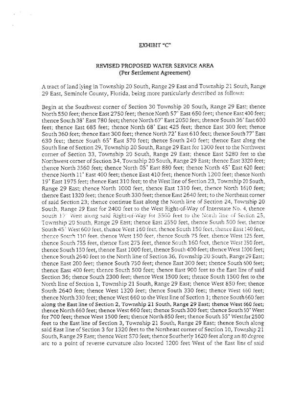
NAME OF COMPANY Sanlando Utilities Corporation
DESCRIPTION OF TERRITORY SERVED
Composite Water Service Area
Seminole County
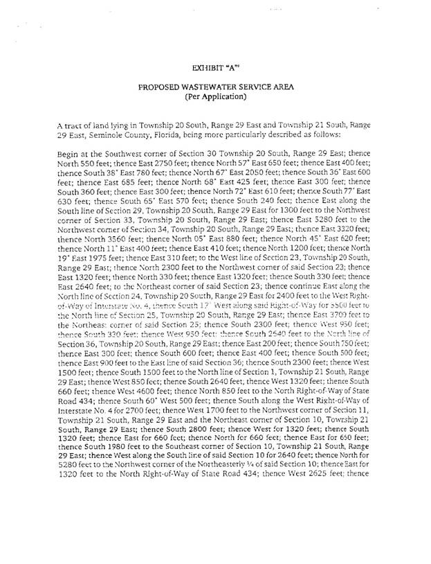
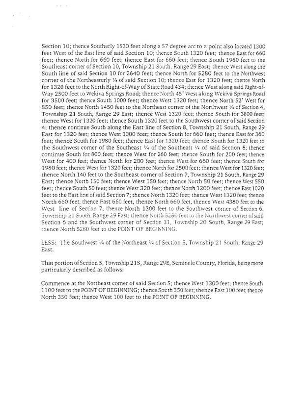
A tract of land lying in Township 20 South, Range 29 East and Township 21 South, Range 29 East, Seminole County, Florida, being more particularly described as follows:
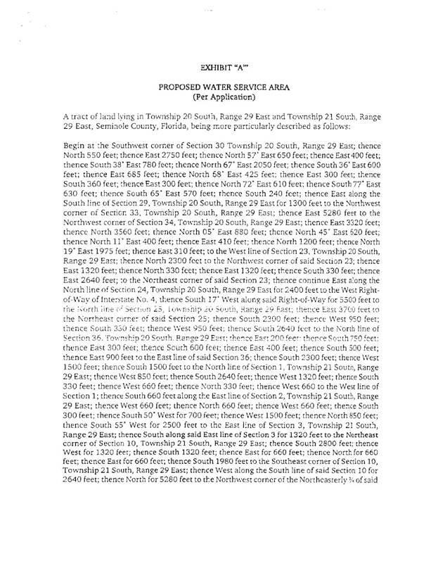
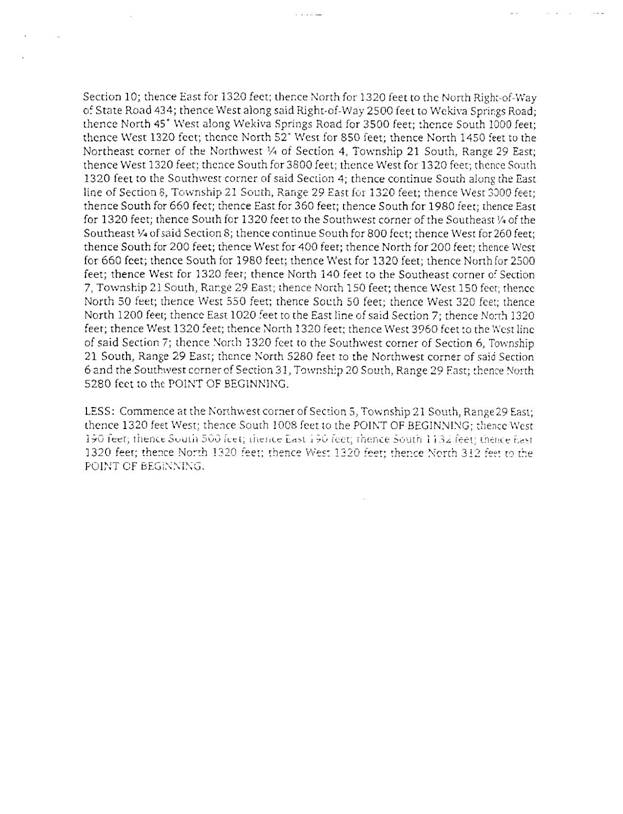
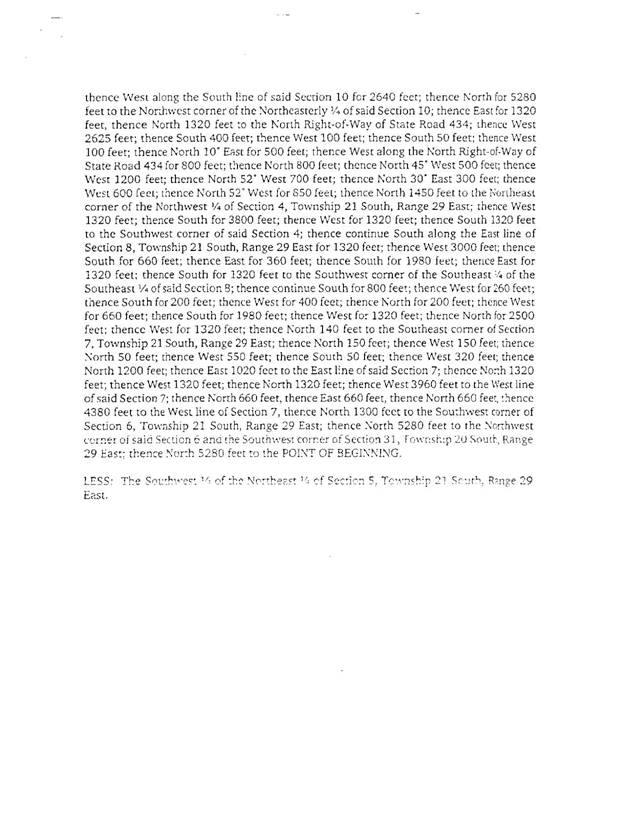
Begin at the Southwest corner of Section 30 Township 20 South, Range 29 East; thence North 550 feet; thence East 2750 feet; thence North 57° East 650 feet; thence East 400 feet; thence South 38° East 780 feet; thence North 67˚ East 2050 feet; thence South 36˚ East 600 feet; thence East 685 feet; thence North 68˚ East 425 feet; thence East 300 feet; thence South 360 feet; thence East 300 feet; thence North 72˚ East 610 feet; thence South 77˚ East 630 feet; thence South 65˚ East 570 feet; thence South 240 feet; thence East along the South line of Section 29, Township 20 South, Range 29 East for 1300 feet to the Northwest corner of Section 33, Township 20 South, Range 29 East; thence East 5280 feet to the Northwest corner of Section 34, Township 20 South, Range 29 East; thence East 3320 feet; thence North 3560 feet; thence North 05˚ East 880 feet; thence North 45˚ East 620 feet; thence North 11˚ East 400 feet; thence East 410 feet; thence North 1200 feet; thence North 19˚ East 1975 feet; thence East 310 feet; to the West line of Section 23, Township 20 South, Range 29 East; thence North 1000 feet, thence East 1310 feet, thence North 1610 feet; thence East 1320 feet; thence South 330 feet; thence East 2640 feet; to the Northeast corner of said Section 23; thence continue East along the North line of Section 24, Township 20 South, Range 29 East for 2400 feet to the West Right-of-Way of Interstate No. 4, thence South 17˚ West along said Right-of-Way for 5500 feet to the North line of Section 25, Township 20 South, Range 29 East; thence East 2550 feet, thence South 500 feet, thence South 45˚ West 600 feet, thence West 160 feet, thence South 150 feet, thence East 140 feet, thence South 110 feet, thence West 150 feet, thence South 75 feet, thence West 125 feet, thence South 755 feet, thence East 275 feet, thence South 160 feet, thence West 350 feet, thence South 150 feet, thence East 1000 feet, thence South 400 feet; thence West 1000 feet; thence South 2640 feet to the North line of Section 36, Township 20 South, Range 29 East; thence East 200 feet; thence South 750 feet; thence East 300 feet; thence South 600 feet; thence East 400 feet; thence South 500 feet; thence East 900 feet to the East line of said Section 36; thence South 2300 feet; thence West 1500 feet; thence South 1500 feet to the North line of Section 1, Township 21 South, Range 29 East; thence West 850 feet; thence South 2640 feet; thence West 1320 feet; thence South 330 feet; thence West 660 feet; thence North 330 feet; thence West 660 to the West line of Section 1; thence South 660 feet along the East line of Section 2, Township 21 South, Range 29 East; thence West 660 feet; thence North 660 feet; thence West 660 feet; thence South 300 feet; thence South 50˚ West for 700 feet; thence West 1500 feet; thence North 850 feet; thence South 55˚ West for 2500 feet to the East line of Section 3, Township 21 South, Range 29 East; thence South along said East line of Section 3 for 1320 feet to the Northeast corner of Section 10, Township 21 South, Range 29 East; thence West 570 feet; thence Southerly 1620 feet along an 80 degree arc to a point of reverse curvature also located 1200 feet West of the East line of said Section 10; thence Southerly 1530 feet along a 57 degree arc to a point also located 1300 feet West of the East line of said Section 10; thence South 1320 feet; thence East for 660 feet; thence North for 660 feet; thence East for 660 feet; thence South 1980 feet to the Southeast corner of Section 10, Township 21 South, Range 29 East; thence West along the South line of said Section 10 for 2640 feet; thence North for 5280 feet to the Northwest corner of the Northeasterly ¼ of said Section 10; thence East for 1320 feet; thence North for 1320 feet to the North Right-of-Way of State Road 434; thence West along said Right-of-Way 2500 feet to Wekiva Springs Road; thence North 45̊ West along Wekiva Springs Road for 3500 feet; thence South 1000 feet; thence West 1320 feet; thence North 52˚ West for 850 feet; thence North 1450 feet to the Northeast corner of the Northwest ¼ of Section 4, Township 21 South, Range 29 East; thence West 1320 feet; thence South for 3800 feet; thence West for 1320 feet; thence South 1320 feet to the Southwest corner of said Section 4; thence continue South along the East line of Section 8, Township 21 South, Range 29 East for 1320 feet; thence West 3000 feet; thence South for 660 feet; thence East for 360 feet; thence South for 1980 feet; thence East for 1320 feet; thence South for 1320 feet to the Southwest corner of the Southeast ¼ of the Southeast ¼ of said Section 8; thence continue South for 800 feet; thence West for 260 feet; thence South for 200 feet; thence West for 400 feet; thence North for 200 feet; thence West for 660 feet; thence South for 1980 feet; thence West for 1320 feet; thence North for 2500 feet; thence West for 1320 feet; thence North 140 feet to the Southeast corner of Section 7, Township 21 South, Range 29 East; thence North 150 feet; thence West 150 feet; thence North 50 feet; thence West 550 feet; thence South 50 feet; thence West 320 feet; thence North 1200 feet; thence East 1020 feet to the East line of said Section 7; thence North 1320 feet; thence West 1320 feet; thence North 660 feet, thence East 660 feet, thence North 660 feet, thence West 4380 feet to the West line of Section 7, thence North 1300 feet to the Southwest corner of Section 6, Township 21 South, Range 29 East; thence North 5280 feet to the Northwest corner of said Section 6 and the Southwest corner of Section 31, Township 20 South, Range 29 East; thence North 5280 feet to the POINT OF BEGINNING.
LESS: The Southwest ¼ of the Northeast ¼ of Section 5, Township 21 South, Range 29 East.
That portion of Section 5, Township 21S, Range 29E, Seminole County, Florida, being more particularly described as follows: Commence at the Northeast corner of said Section 5; thence West 1300 feet; thence South 1100 feet to the POINT OF BEGINNING; thence South 350 feet; thence East 100 feet; thence North 350 feet; thence West 100 feet to the POINT OF BEGINNING.
NAME OF COMPANY Sanlando Utilities Corporation
DESCRIPTION OF TERRITORY SERVED
Composite Wastewater Service Area
Seminole County
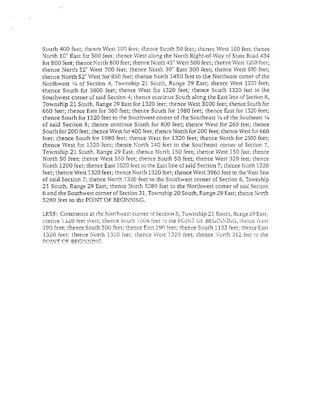
A tract of land lying in Township 20 South, Range 29 East and Township 21 South, Range 29 East, Seminole County, Florida, being more particularly described as follows:
Begin at the Southwest corner of Section 30 Township 20 South, Range 29 East; thence North 550 feet; thence East 2750 feet; thence North 57˚ East 650 feet; thence East 400 feet; thence South 38˚ East 780 feet; thence North 67˚ East 2050 feet; thence South 36˚ East 600 feet; thence East 685 feet; thence North 68˚ East 425 feet; thence East 300 feet; thence South 360 feet; thence East 300 feet; thence North 72˚ East 610 feet; thence South 77˚ East 630 feet; thence South 65˚ East 570 feet; thence South 240 feet; thence East along the South line of Section 29, Township 20 South, Range 29 East for 1300 feet to the Northwest corner of Section 33, Township 20 South, Range 29 East; thence East 5280 feet to the Northwest corner of Section 34, Township 20 South, Range 29 East; thence East 3320 feet; thence North 3560 feet; thence North 05˚ East 880 feet; thence North 45˚ East 620 feet; thence North 11˚ East 400 feet; thence East 410 feet; thence North 1200 feet; thence North 19˚ East 1975 feet; thence East 310 feet; to the West line of Section 23, Township 20 South, Range 29 East; thence North 1000 feet, thence East 1310 feet, thence North 1610 feet; thence East 1320 feet; thence South 330 feet; thence East 2640 feet; to the Northeast corner of said Section 23; thence continue East along the North line of Section 24, Township 20 South, Range 29 East for 2400 feet to the West Right-of-Way of Interstate No. 4, thence South 17˚ West along said Right-of-Way for 5500 feet to the North line of Section 25, Township 20 South, Range 29 East; thence East 2550 feet, thence South 500 feet, thence South 45˚ West 600 feet, thence West 160 feet, thence South 150 feet, thence East 140 feet, thence South 110 feet, thence West 150 feet, thence South 75 feet, thence West 125 feet, thence South 755 feet, thence East 275 feet, thence South 160 feet, thence West 350 feet, thence South 150 feet, thence East 1000 feet, thence South 400 feet; thence West 1,000 feet; thence South 2640 feet to the North line of Section 36, Township 20 South, Range 29 East; thence East 560 feet; thence South 1300 feet; thence East 420 feet; thence South 420 feet; thence East 930 feet to the East line of said Section 36; thence South 2300 feet; thence West 1500 feet; thence South 1500 feet to the North line of Section 1, Township 21 South, Range 29 East; thence West 850 feet; thence South 2640 feet; thence West 1320 feet; thence South 660 feet; thence West 4600 feet; thence North 850 feet to the North Right-of-Way of State Road 434; thence South 60̊ West 500 feet; thence South along the West Right-of-Way of Interstate No. 4 for 2700 feet; thence West 1700 feet to the Northwest corner of Section 11, Township 21 South, Range 29 East and the Northeast corner of Section 10, Township 21 South, Range 29 East; thence South 1350 feet; thence West for 1200 feet; thence Southerly 1530 feet along a 57 degree arc; thence South 1320 feet; thence East for 660 feet; thence North for 660 feet; thence East for 660 feet; thence South 1980 feet to the Southeast corner of Section 10, Township 21 South, Range 29 East; thence West along the South line of said Section 10 for 2640 feet; thence North for 5280 feet to the Northwest corner of the Northeasterly ¼ of said Section 10; thence East for 1320 feet, thence North 1320 feet to the North Right-of-Way of State Road 434; thence West 2625 feet; thence South 400 feet; thence West 100 feet; thence South 50 feet; thence West 100 feet; thence North 10̊ East for 500 feet; thence West along the North Right-of-Way of State Road 434 for 800 feet; thence North 800 feet; thence North 45˚ West 500 feet; thence West 1200 feet; thence North 52˚ West 700 feet; thence North 30˚ East 300 feet; thence West 600 feet; thence North 52˚ West for 850 feet; thence North 1450 feet to the Northeast corner of the Northwest ¼ of Section 4, Township 21 South, Range 29 East; thence West 1320 feet; thence South for 3800 feet; thence West for 1320 feet; thence South 1320 feet to the Southwest corner of said Section 4; thence continue South along the East line of Section 8, Township 21 South, Range 29 East for 1320 feet; thence West 3000 feet; thence South for 660 feet; thence East for 360 feet; thence South for 1980 feet; thence East for 1320 feet; thence South for 1320 feet to the Southwest corner of the Southeast ¼ of the Southeast ¼ of said Section 8; thence continue South for 800 feet; thence West for 260 feet; thence South for 200 feet; thence West for 400 feet; thence North for 200 feet; thence West for 660 feet; thence South for 1980 feet; thence West for 1320 feet; thence North for 2500 feet; thence West for 1320 feet; thence North 140 feet to the Southeast corner of Section 7, Township 21 South, Range 29 East; thence North 150 feet; thence West 150 feet; thence North 50 feet; thence West 550 feet; thence South 50 feet; thence West 320 feet; thence North 1200 feet; thence East 1020 feet to the East line of said Section 7; thence North 1320 feet; thence West 1320 feet; thence North 1320 feet; thence West 3960 feet to the West line of said Section 7; thence North 660 feet, thence East 660 feet, thence North 660 feet, thence 4380 feet to the West line of Section 7, thence North 1300 feet to the Southwest corner of Section 6, Township 21 South, Range 29 East; thence North 5280 feet to the Northwest corner of said Section 6 and the Southwest corner of Section 31, Township 20 South, Range 29 East; thence North 5280 feet to the POINT OF BEGINNING.
LESS: The Southwest ¼ of the Northeast ¼ of Section 5, Township 21 South, Range 29 East.