Discussion
of Issues
Issue 1:
Should the application for transfer of majority
organizational control of First Coast Regional Utilities, Inc., holder of water
Certificate No. 680-W and wastewater Certificate No. 578-S in Duval, Baker, and
Nassau Counties, from Roberts Utility Holdings, LLC to Florida Water Holdings,
Inc. be approved?
Recommendation:
Yes. The transfer of majority organizational control
from RUH to FWH is in the public interest and should be approved effective the
date of the Commission vote. The resultant order should serve as the water and
wastewater certificates, with the territories described in Attachment A. The Buyer should file a notice of closing in the docket
file within 60 days of the Order approving the transfer, which is final agency
action. If the sale is not finalized within 60 days of the transfer Order, the
Buyer should file a status update in the docket file. The Utility’s
existing rates and charges should remain in effect until a change is authorized
by the Commission in a subsequent proceeding. The tariff sheets reflecting the
transfer should be effective on or after the stamped approval date on the
tariff sheets pursuant to Rule 25-30.475(1), Florida Administrative Code,
(F.A.C.). Based on the application, the Buyer will be responsible for filing
annual reports and paying regulatory assessment fees (RAFs) after the closing date.
(Ramirez-Abundez, Bethea, Fisher, McClelland, Rauch)
Staff
Analysis:
On June 24, 2026, an application was filed for the transfer
of majority organization control of First Coast in Duval, Baker, and Nassau
counties from RUH to FWH. Based on staff’s review, the application is in
compliance with Section 367.071, F.S., and Rule 25-30.037(4), F.A.C.,
concerning application for transfer of majority organizational control. The
purchase agreement is structured as a purchase of 100 percent of the issued and
outstanding stock and is not an asset acquisition. The transfer of majority
organizational control of First Coast pursuant to the purchase agreement is
subject to the Commission’s approval, and according to the application, the
closing will occur within 30 days after approval and satisfaction of all
remaining closing conditions.
Legal Standard
Section 367.071(1), F.S., provides that no utility shall
transfer its certificate of authorization, facilities or any portion thereof,
or majority organizational control without determination and approval of the
Commission that the proposed transfer is in the public interest and that the
buyer, assignee, or transferee will fulfill the commitments, obligations, and
representations of the utility. However, a transfer of certificate of
authorization, facilities or any portion thereof, or majority organizational control
may occur prior to Commission approval if the contract for sale, assignment, or
transfer is made contingent upon Commission approval.
Noticing and Territory
First Coast provided notice of the application pursuant to
Section 367.071, F.S., and Rule 25-30.030, F.A.C. No objections to the transfer
were filed with the Commission, and the time for doing so has expired. The
notice contained a simplified territory description for First Coast, and the
complete description is appended to this recommendation as Attachment A.
Technical and Financial Ability
Pursuant to Rules 25-30.037(2)(l) and (m), F.A.C., the
application contains statements describing the technical and financial ability
of the Buyer to provide service. According to the application, and as stated in
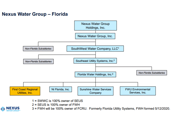
the case background, FWH is wholly owned by SEUS, and both entities are holding
companies without direct operations or financial statements. SEUS is an indirectly
owned subsidiary of Nexus Water Group, Inc. (Nexus), which is a holding company
that has indirectly owned and operated private water and wastewater utilities throughout
the state of Florida since 1976. Nexus’ Florida subsidiaries, Sunshine Water
Services Company (SWS) and Ni Florida, LLC (Ni FL), provide water and
wastewater service to over 36,000 water and 33,000 wastewater customers in
Florida. A diagram of the complete organizational structure of FWH and its
affiliates is included in Attachment B.
FWH indicated that it has the managerial and operational
expertise to operate water and wastewater systems by and through the resources
and staff of its affiliates. The Buyer stated that First Coast’s day-to-day
operations will be led by Nexus’ Florida management team, which is the same
management team that oversees SWS and Ni FL.
This management team is expected to provide the support capabilities necessary to
successfully operate First Coast, including safety, compliance, operational
oversight, financial and project management, billing and customer service,
human resources, and administration. In addition, although First Coast’s water
and wastewater systems are currently under design and construction, FWH expects
that First Coast will need additional employees to operate the site facilities
once they become operational.
The
transfer application states that the Buyer has sufficient financial assets to
ensure the continuing operation of the Utility. Staff reviewed the financial
statements of the Buyer and believes it has the financial capability to ensure
any necessary funding. According to the application, the public interest is
served by the Buyer. Based on the above, the Buyer, with the support of
its affiliates, has demonstrated the technical and financial ability to provide
service to the existing service territory.
Rates, Charges, and
Deposits
The
Utility’s rates, miscellaneous service charges, late payment charge,
non-sufficient funds (NSF), initial customer deposits, and service availability
charges were established in an original certificate case in 2022.[4] Recently, the Commission
approved revised service availability charges.[5]
Rule 25-9.044(1), F.A.C., provides that, in the case of a change of ownership
or control of a utility the rates, classifications, and regulations of the
former owner must continue unless authorized to change by the Commission.
Therefore, staff recommends that the Utility’s existing rates, charges, and
deposits as shown on Schedules No. 1-A and 1-B, should remain in effect, until
a change is authorized by the Commission in a subsequent proceeding. The tariff
sheets reflecting the transfer should be effective on or after the stamped
approval date on the tariff sheets pursuant to Rule 25-30.475(1), F.A.C.
Conclusion
Based on the above, staff recommends that the transfer of
the majority organizational control from RUH to FWH is in the public interest
and should be approved effective the date of the Commission vote. The resultant
order should serve as the water and wastewater certificate, with the
territories described in Attachment A. The Buyer should file a notice of
closing in the docket file within 60 days of the Order approving the transfer,
which is final agency action. If the sale is not finalized within 60 days of
the transfer Order, the Buyer should file a status update in the docket file.
The Utility’s existing rates and charges should remain in effect until a change
is authorized by the Commission in a subsequent proceeding. The tariff sheets
reflecting the transfer should be effective on or after the stamped approval
date on the tariff sheets pursuant to Rule 25-30.475(1), F.A.C. Based on the
application, the Buyer will be responsible for filing annual reports and paying
regulatory assessment fees (RAFs) after the closing date.
Issue
2:
Should this docket be closed?
Recommendation:
Yes. If the Commission approves staff’s
recommendation in Issue 1, this docket should be closed. (Rauch)
Staff Analysis:
If the Commission approves staff’s recommendation in
Issue 1, this docket should be closed.
First Coast Regional Utilities, Inc.
Duval,
Baker, and Nassau Counties
Water
and Wastewater Service Area
301 Parcel
A portion of Sections
28, 31, 32 and 33, Township 2 South, Range 23 East, all of Sections 4, 5, 6, 7,
8, 9 and 17, and a portion of Sections 3, 10, 15, 16, 18, 19, 20, 21, 28, 29
and 30, Township 3 South, Range 23 East, Duval County, Florida, together with a
portion of Sections 25, 26, 27, 33, 34, 35 and 36, Township 2 South, Range 22
East, all of Sections 12, 13 and 24, and a portion of Sections 1, 2, 3, 11, 14,
23, 25 and 26, Township 3 South, Range 22 East, Baker County, Florida, together
with a portion of Sections 29, 30 and 31, Township 2 South, Range 23 East,
Nassau County, Florida, being more particularly described as follows:
For a Point of
Reference, commence at the Southwest corner of Section 31, said Township 2
South, Range 23 East; thence North 00°01’21”
West, along the Westerly line of said Section
31, a distance of 2796.10 feet to the Point of Beginning.
From said Point of Beginning, thence
continue North 00°01’21” West, along said Westerly line of
Section 31, a distance of 279.43 feet to its intersection with the
Northerly limited access right of way line of Interstate No. 10 (State Road No.
8), a 300 foot limited access right of way at this point, as presently
established; thence Southwesterly along said Northerly limited access right of
way line the following 3 courses: Course 1, thence South 77°26’31” West,
departing said Westerly line, 4622.69 feet to the point of curvature of a curve
concave Southerly having a radius of 11,594.04 feet; Course 2, thence Westerly
along the arc of said curve, through a central angle of 14°51’39”, an arc
length of 3007.15 feet to the point of tangency of said curve, said arc being
subtended by a chord bearing and distance of South 70°00’41” West, 2998.73
feet; Course 3, thence South 62°34’52” West, 9297.94 feet to its intersection
with the Easterly line of Section 4, Township 35, Range 22 East; thence North
00°20’32” West, departing said Northerly limited access right of way line and
along said Easterly line, 1181.59 feet; thence North 00°12’44” West, continuing
along said Easterly line, 1537.23 feet to the Northeast corner of Section 4,
said Township 3 South, Range 22 East; thence South 87°56’40” West, along the
Northerly line of last said Section 4, a distance of 2641.22 feet; thence North
12°20’13” West, departing said Northerly line, 1343.87 feet; thence South
89°13’11” West, 320.43 feet; thence North 01°12’19” West, 2541.27 feet to a
point lying on the Southerly right of way line of CSX Railroad, a variable
width right of way as presently established; thence Easterly along said
Southerly right of way line the following 3 courses: Course 1, thence North
77°39’30” East, 1151.90 feet; Course 2, thence North 77°38’43” East, 2042.04
feet; Course 3, thence North 77°37’43” East, 1372.71 feet; thence North 07°53’20”
West, departing said Southerly right of way line, 348.00 feet to a point lying
on the Southerly right of way line of U.S. Highway No. 90 (State Road No. 10),
a variable width right of way as presently established; thence North 77°50’40”
East, along said Southerly right of way line, 477.82 feet; thence North
77°49’28” East, continuing along said Southerly right of way line, 4077.64
feet; thence South 12°21’52” West, departing said Southerly right of way line,
365.87 feet to a point lying on said Southerly right of way line of CSX
Transportation Railroad; thence North 77°38’43” East, along said Southerly
right of way line, 243.87 feet; thence North 77°40’43” East, continuing along
said Southerly right of way line, 1121.92 feet; thence North 11°15’34” West,
departing said Southerly right of way line, 329.25 feet to a point lying on
said Southerly right of way line of U.S. Highway No. 90; thence Easterly along
said Southerly right of way line the following 3 courses: Course 1, thence
North 77°49’28” East, 1371.16 feet to the point of curvature of a curve concave
Southerly having a radius of 5689.66 feet; Course 2, thence Easterly along the
arc of said curve, through a central angle of 04°07’57”, an arc length of
410.38 feet to the point of tangency of said curve, said arc being subtended by
a chord bearing and distance of North 79°53’27” East, 410.29 feet; Course 3,
thence North 81°57’25” East, 528.43 feet; thence South 00°57’44” West,
departing said Southerly right of way line, 1080.73 feet; thence North 89°39’11”
East, 1368.16 feet; thence North 02°26’55” West, 1256.61 feet to a point lying
on said Southerly right of way line of U.S. Highway No. 90; thence
Northeasterly along the Southerly and Southeasterly right of way line of said
U.S. Highway No. 90 the following 13 courses: Course 1, thence North
81°57’25” East, 5326.11 feet; Course 2, thence North 83°43’11” East,
35.46 feet to the point of curvature of a curve concave Northwesterly having a
radius of 1465.39 feet; Course 3, thence Northeasterly along the arc of said
curve, through a central angle of 17°28’30”, an arc length
of 446.94 feet to the point of tangency of said curve, said arc being subtended
by a chord bearing and distance of North 74°58’56” East, 445.21
feet; Course 4, thence North 66°14’41” East, 2919.19 feet; Course 5, thence
South 23°45’19”
East, 67.00 feet; Course 6, thence North 66°14’41” East, 2423.53
feet to a point lying on the Westerly line of said Section 29, Township 2
South, Range 23 East; Course 7, thence North 01°03’23” East, along said
Westerly line, 73.81 feet; Course 8, thence North 66°14’41”
East, departing said Westerly line, 473.55 feet; Course 9, thence South 23°45’19”
East, 24.28 feet; Course 10, thence North 66°14’41” East, 820.21
feet; Course 11, thence North 23°45’19” West, 24.28
feet; Course 12, thence North 66°14’41” East, 1328.45
feet to the point of curvature of a curve concave Southeasterly having a radius
of 1399.39 feet; Course 13, thence Northeasterly along the arc of said curve,
through a central angle of 12°25’11”, an arc length of 303.34 feet a
point on said curve, said arc being subtended by a chord bearing and distance
of North 72°27’16”
East, 302.75 feet; thence South 00°37’00” West, departing
said Southeasterly right of way line, 2636.77 feet to a point lying on the
Northerly right of way line of said CSX Railroad; thence Westerly along said
Northerly right of way line the following 3 courses: Course 1, thence South 83°25’36”
West, 50.82 feet; Course 2, thence South 02°02’34” West, 50.57
feet; Course 3, thence South 83°25’36” West, 430.31
feet; thence North 89°45’25” West, departing said Northerly
right of way line, 891.56 feet; thence South 00°17’37” West, 1369.31
feet; thence South 89°48’34” West, 1336.66 feet to a point
lying on the Westerly line of said Section 29 Township 25, Range 23 East;
thence South 01°03’23” West, along said Westerly line,
1367.61 feet to the Southwest corner of said last Section 29; thence North 89°46’35”
East, along the Southerly line of last said Section 29, a distance of 5419.51 feet
to the Southeast corner thereof; thence North 00°09’35” East, along the
Easterly line of last said Section 29, a distance of 2685.44 feet; thence North
89°51’30” East, departing said Easterly line, 2349.72 feet; thence South
01°00’44” West, 2699.45 feet to a point lying on the Southerly line of said
Section 28 Township 25, Range 23 East; thence North 89°56’32” East, along said
Southerly line, 990.82 feet to a point lying on the Northerly limited access
right of way line of Interstate No. 10 (State Road No. 8) a variable width
limited access right of way per Florida Department of Transportation Right of
Way Map Section 72270-2401; thence Southwesterly along said Northerly limited
access right of way line the following 3 courses: Course 1, thence South 85°45’37”
West, departing said Southerly line, 4434.27 feet to the point of curvature of
a curve concave Southerly having a radius of 23068.31 feet; Course 2, thence
Westerly along the arc of said curve, through a central angle of 06°33’27”,
an arc length of 2640.17 feet to the point of tangency of said curve, said arc
being subtended by a chord bearing and distance of South 82°28’54”
West, 2638.73 feet; Course 3, thence South 79°12’10” West, 3013.43 feet; thence
South 46°06’56” West, departing said Northerly limited access right of way
line, 4887.43 feet; thence Due South, 438.28 feet; thence South 89°08’52” East,
4708.98 feet; thence North 89°59’13” East, 5245.32 feet; thence South 89°47’34”
East, 5252.38 feet; thence North 89°36’51” East, 833.91 feet; thence South
29°17’25” East, 198.21 feet; thence South 50°34’45” East, 114.79 feet; thence
South 38°07’06” East, 849.24 feet to the point of curvature of a curve concave
Northeasterly having a radius of 520.00 feet; thence Southeasterly along the
arc of said curve, through a central angle of 46°18’27”, an arc length of
420.27 feet to the point of tangency of said curve, said arc being subtended by
a chord bearing and distance of South 61°16’20” East, 408.93 feet; thence South
84°25’33” East, 493.91 feet to the point of curvature of a curve concave
Northerly having a radius of 1000.00 feet; thence Easterly along the arc of
said curve, through a central angle of 13°01’31”, an arc length of 227.33 feet
to the point of tangency of said curve, said arc being subtended by a chord
bearing and distance of North 89°03’42” East, 226.84 feet; thence North
82°32’56” East, 145.54 feet; thence North 89°27’34” East, 771.07 feet to a
point lying on the Westerly right of way line of U.S. Highway No. 301, a
variable width right of way as presently established; thence Southwesterly
along said Westerly right of way line the following 5 courses: Course 1, thence
South 18°55’48” West, 1785.80 feet; Course 2, thence South 18°55’47” West,
5851.81 feet; Course 3, thence South 18°56’27” West, 1781.26 feet; Course 4,
thence North 71°02’55” West, 32.00 feet; Course 5, thence South 18°57’05” West,
1024.91 feet; thence North 00°30’52” East, departing said Westerly right of way
line, 459.40 feet to a point lying on the Northerly line of said Section 15;
thence North 89°30’18” West, departing said Easterly line and along said
Northerly line, 105.00 feet, thence North 01°10’37” East, departing said
Northerly line of Section 15, a distance of 225.00 feet; thence North 89°30’18”
West, 225.00 feet to a point lying on the Westerly line of said Section 10;
thence South 01°10’37” West, along said Westerly line, 225.00 feet to the
Northwest corner of said Section 15; thence South 00°30’52” West, along the
Westerly line of said Section 15, a distance of 990.00 feet; thence South
89°30’18” East, departing said Westerly line, 153.09 feet to a point lying on
said Westerly right of way line of U.S. Highway No. 301; thence Southwesterly
along said Westerly right of way line the following 9 courses: Course 1, thence
South 18°57’05” West, 4565.72 feet; Course 2, thence South 71°18’37” East,
32.09 feet; Course 3, thence South 18°48’12” West, 91.40 feet; Course 4, thence
South 19°02’58” West, 1903.63 feet; Course 5, thence South 18°58’32” West,
854.92 feet; Course 6, thence North 71°01’28” West, 22.00 feet; Course 7,
thence South 18°58’00” West, 3713.49 feet; Course 8, thence South 71°02’00”
East, 22.00 feet; Course 9, thence South 18°58’03” West, 238.56 feet; thence
South 89°56’02” West, departing said Westerly right of way line, 1035.38 feet;
thence South 00°19’39” West, 1326.85 feet; thence South 89°51’06” East, 586.01
feet to a point lying on said Westerly right of way line of U.S. Highway No.
301; thence South 18°58’03” West, along said Westerly right of way line, 411.90
feet; thence North 71°00’26” West, departing said Westerly right of way line,
161.05 feet; thence South 18°59’34” West, 180.00 feet; thence North 71°00’26”
West, 90.00 feet; thence North 18°59’34” East, 180.00 feet; thence North
71°00’26” West, 390.00 feet; thence South 18°59’34” West, 180.00 feet; thence
North 71°00’26” West, 30.00 feet; thence South 18°59’36” West, 80.00 feet;
thence South 18°54’10” West, 178.95 feet; thence North 71°05’50” West, 135.00
feet; thence South 18°54’10” West, 258.34 feet; thence South 71°05’50” East,
255.00 feet; thence South 18°54’10” West, 178.34 feet; thence South 71°05’50”
East, 45.00 feet; thence North 18°54’10” East, 436.68 feet; thence North
71°05’50” West, 45.00 feet; thence North 18°54’10” East, 178.77 feet; thence
South 71°00’26” East, 551.17 feet to a point lying on said Westerly right of
way line of U.S. Highway No. 301; thence South 18°58’03” West, along said
Westerly right of way line, 356.24 feet; thence North 71°05’50” West, departing
said Westerly right of way line, 280.76 feet; thence South 18°54’10” West,
258.34 feet; thence North 71°05’50” West, 45.00 feet; thence South 18°54’10”
West, 258.34 feet; thence South 71°05’50” East, 45.00 feet; thence South
18°54’10” West, 356.69 feet; thence North 71°05’50” West, 405.37 feet to a
point lying on the Easterly line of said Section 29, Township 3 South, Range 23
East; thence North 00°19’41” East, along said Easterly line, 4219.23 feet to
the corner common to said Sections 20, 21, 28 and 29, last said Township and Range;
thence North 89°51’06” West, along the Northerly line of last said Section 29,
a distance of 2621.91 feet; thence South 00°32’07” West, departing said
Northerly line, 3956.58 feet; thence South 89°57’47” East, 1250.59 feet; thence
South 00°18’53” West, 1071.87 feet to the Northerly right of way line of County
Road No. 228 (Maxville Macclenny Highway), a variable width right of way as
presently established; thence Westerly along said Northerly right of way line
the following 3 courses: Course 1, thence South 86°24’08” West, 2689.67 feet to
the point of curvature of a curve concave Northerly having a radius of 11399.16
feet; Course 2, thence Westerly along the arc of said curve, through a central
angle of 03°50’21”, an arc length of 763.84 feet to the point of tangency of
said curve, said arc being subtended by a chord bearing and distance of South
88°19’19” West, 763.70 feet; Course 3, thence North 89°45’30” West, 2988.94
feet; thence North 00°37’29” West, departing said Northerly right of way line,
1266.06 feet; thence North 89°48’21” West, 1329.53 feet; thence North 89°59’50”
West, 1293.71 feet to a point lying on the Westerly line of said Section 30
Township 35, Range 23 East; thence South 00°25’12” West, along said Westerly
line, 1197.72 feet to a point lying on the Northeasterly right of way line of
said County Road No. 228; thence Northwesterly along said Northeasterly right
of way line the following 5 courses: Course 1, thence South 00°27’02” West,
continuing along said Westerly line, 10.22 feet to a point on a curve concave
Northeasterly having a radius of 2814.79 feet; Course 2, thence Northwesterly,
departing said Westerly line and along the arc of said curve, through a central
angle of 29°38’35”, an arc length of 1456.29 feet to the point of tangency of
said curve, said arc being subtended by a chord bearing and distance of North
62°56’16” West, 1440.10 feet; Course 3, thence North 48°06’59” West, 4279.13
feet; Course 4, thence North 48°05’02” West, 1951.98 feet to a point on a curve
concave Northeasterly having a radius of 1742.47 feet; Course 5, thence
Northwesterly along the arc of said curve, through a central angle of
19°23’33”, an arc length of 589.77 feet to its intersection with the Southerly
line of said Section 23, said arc being subtended by a chord bearing and
distance of North 38°18’20” West, 586.95 feet; thence North 88°35’30” West,
departing said Northeasterly right of way line and along said Southerly line,
330.65 feet; thence North 01°11’40” East, departing said Southerly line, 22.27
feet; thence North 48°06’08” West, 758.73 feet to a point on a curve concave
Northeasterly having a radius of 3645.43 feet; thence Northwesterly along the
arc of said curve, through a central angle of 43°58’14”, an arc length of
2797.61 feet to a point on said curve, said arc being subtended by a chord
bearing and distance of North 26°03’11” West, 2729.46 feet; thence North
04°00’15” West, 7196.95 feet to the point of curvature of a curve concave
Westerly having a radius of 1345.00 feet; thence Northerly along the arc of
said curve, through a central angle of 29°32’07”, an arc length of 693.33 feet
to a point on said curve, said arc being subtended by a chord bearing and
distance of North 18°46’19” West, 685.68 feet; thence North 49°13’56” East,
9.19 feet to a point lying on the Southwesterly right of way line of said
County Road No. 228; thence North 40°46’21” West, along said Southwesterly
right of way line, 1001.38 feet; thence North 75°50’34” East, departing said
Southwesterly right of way line, 1401.89 feet to the point of curvature of a
curve concave Northwesterly having a radius of 1909.86 feet; thence
Northeasterly, along the arc of said curve, through a central angle of
41°38’58”, an arc length of 1388.32 feet to the point of tangency of said curve,
said arc being subtended by a chord bearing and distance of North 55°01’07”
East, 1357.95 feet; thence North 34°11’36” East, 13246.82 feet to a point lying
on the Southerly limited access right of way line of said Interstate No. 10, a
330 foot limited access right of way as presently established; thence North
79°12’10” East, along said Southerly limited access right of way line, 51.63
feet to the Point of Beginning.
Less and Except from the above described
lands the following:
Exception Parcel
A (Revised)
A portion of Sections 18 and 19, Township
3 South, Range 23 East, Jacksonville, Duval County, Florida, being more
particularly described as follows:
For a Point of Reference, commence at the
Southwest corner of said Section 19; thence North 00°28’56” East, along the
West line of said Section 19, a distance of 1000.02 feet to the Point of
Beginning.
From said Point of Beginning, thence
continue North 00°28’56” East, along said West line
of Section 19, a distance of 4246.29 feet to the Northwesterly corner thereof;
thence North 00°28’20” East, along the West line of said Section 18, a distance
of 4646.30 feet; thence South 89°40’53” East, departing said West line, 4665.72
feet; thence South 00°54’39” West, 4625.31 feet to a point lying on the South line
of said Section 18; thence South 00°53’22” West, 682.99 feet; thence South
89°06’38” East, 616.98 feet to a point lying on the East line of said Section
19; thence South 00°53’22” West, along said East line, 700.02 feet; thence
North 89°06’38” West, departing said East line, 616.98 feet; thence South
00°53’22” West, 2871.05 feet; thence North 89°51’04” West, 4600.88 feet to the
Point of Beginning.
Exception Parcel B
A portion of Section 20, Township 3
South, Range 23 East, Jacksonville, Duval County, Florida, being more
particularly described as follows:
For a Point of Reference, begin at the
Northwest corner of said Section 20; thence South 00°53’22” West, along the
West line of said Section 20, a distance of 1091.96 feet to the Point of Beginning.
From said Point of Beginning, thence
North 89°38’47” East, departing said West line, 1396.84 feet; thence South
73°54’19” East, 624.12 feet; thence South 69°40’09” East, 1692.00 feet; thence
South 58°49’25” East, 1913.07 feet to a point lying on the East line of said
Section 20; thence South 00°55’09” West, along said East line, 127.49 feet;
thence North 48°44’13” West, departing said East line, 57.82 feet; thence North
58°49’25” West, 1910.90 feet; thence North 69°40’09” West, 1678.81 feet; thence
North 73°54’19” West, 605.97 feet; thence South 89°38’47” West, 1384.55 feet to
a point lying on the West line of said Section 20; thence North 00°53’22” East,
along said West line, 100.02 feet to the Point of Beginning.
Exception Parcel C (Revised)
A portion of Section 21, Township 3
South, Range 23 East, Jacksonville, Duval County, Florida, being more
particularly described as follows:
For a Point of Reference, commence at the
Southwest corner of said Section 21; thence North 00°55’09” East, along the
West line of said Section 21, a distance of 2305.48 feet to the Point of
Beginning.
From said Point of Beginning, thence
continue North 00°55’09” East, along said West line, 127.49 feet; thence South
49°30’26” East, departing said West line, 210.33 feet; thence South 48°44’13”
East, 1989.21 feet; thence North 41°15’47” East, 85.00 feet; thence South
48°44’13” East, 217.74 feet to the point of curvature of a curve concave
Northeasterly and having a radius of 576.50 feet; thence Southeasterly, along
and around the arc of said curve, through a central angle of 11°14’16”, an arc
distance of 113.07 feet to the point of tangency of said curve, said arc being
subtended by a chord bearing and distance of South 54°21’21” East, 112.89 feet;
thence South 59°58’29” East, 120.84 feet to the point of curvature of a curve
concave Northeasterly and having a radius of 643.90 feet; thence Southeasterly,
along and around the arc of said curve, through a central angle of 11°00’00”,
an arc distance of 123.62 feet to the point of tangency of said curve, said arc
being subtended by a chord bearing and
distance of South 65°28’29” East, 123.43 feet; thence South 70°58’29” East,
146.25 feet to a point lying on the Westerly right-of-way line of U.S. Highway
No. 301, a variable width right of way as presently established; thence South
18°58’00” West, along said Westerly right-of-way line, 397.77 feet; thence
North 48°44’13” West, departing said Westerly right-of-way line, 853.10 feet;
thence North 41°15’47” East, 57.53 feet; thence North 48°44’13” West, 2116.98
feet to the Point of Beginning.
Exception Parcel D
A portion of Sections 13 and 24, Township
3 South, Range 22 East, Baker County, Florida, being more particularly
described as follows:
For a Point of Reference, commence at the
Southeast corner of said Section 24; thence North 00°28’56” East, along the
East line of said Section 24, a distance of 1513.79 feet to the Point of
Beginning.
From said Point of Beginning, thence
North 89°29’14” West, departing said East line of Section 24, a distance of
200.14 feet; thence North 00°29’09” East, 5231.52 feet; thence South 89°30’49”
East, 199.98 feet to a point lying on the East line of said Section 13; thence
South 00°29’20” West, along the East line of said Section 13, a distance of
1499.07 feet to the Northeast corner of said Section 24; thence South 00°28’56”
West, along said East line of Section 24, a distance of 3732.53 feet to the
Point of Beginning.
Less and Except a
portion of Sections 19 and 30, Township 3 South, Range 23 East, Duval County,
Florida, being more particularly described as follows.
For a Point of
Beginning, commence at the Southwest corner of said Section 19, thence North
00°28’56” East, along the Westerly line of said Section 19, a distance of
1000.02 feet; thence South 89°51’04” East, departing said Westerly line,
4600.88 feet; thence South 00°54’03” West, 6225.09 feet to a point lying on the
Northerly right of way line of Maxville Macclenny Highway, a variable width
right of way as presently established; thence North 89°45’30” West, along said
Northerly right of way line, 1906.17 feet; thence North 00°37’29” West,
departing said Northerly right of way line, 1266.06 feet; thence North
89°48’21” West, 1329.53 feet; thence North 89°59’50” West, 1293.71 feet to a
point lying on the Westerly line of said Section 30; thence Northerly along
said Westerly line the following 3 courses: Course 1, thence North 00°28’42”
East, 1318.91 feet; Course 2, thence North 00°27’02” East, 1319.15 feet; Course
3, thence North 00°27’02” East, 1319.77 feet to the Point of Beginning.
Less and Except any portion lying within the limited access right of way of
Interstate No. 10 (State Road No. 8), a variable
width limited access right of way as presently established.
Less and Except any portion lying
within the right of way of County Road No. 228 (Maxville Macclenny Highway), a
variable width right of way as presently established.
Less and Except any portion lying
within the right of way of CSX Railroad, a variable width right of way as
presently established.
Less and except the sovereign
lands of the State of Florida, if any.
Containing 14,111.55 acres, more or less.
FLORIDA PUBLIC SERVICE COMMISSION
Authorizes
First Coast Regional Utilities, Inc.
pursuant to
Certificate Number 680-W
to provide water service in Baker,
Duval, and Nassau Counties in accordance with the provisions of Chapter
367, Florida Statutes, and the Rules, Regulations, and Orders of this
Commission in the territory described by the Orders of this Commission. This
authorization shall remain in force and effect until superseded, suspended,
cancelled or revoked by Order of this Commission.
|
Order Number
|
Dated Issued
|
Docket Number
|
Filing Type
|
|
PSC-2022-0193-FOF-WS
|
05/25/2022
|
20190168-WS
|
Original Certificate
|
|
PSC-2026-0074-FOF-WS
|
03/23/2026
|
20250125-WS
|
Amendment of Certificate
|
|
*
|
*
|
20260095-WS
|
Transfer of Majority Org. Control
|
* Order Number and
date to be provided at time of issuance.
FLORIDA PUBLIC SERVICE COMMISSION
Authorizes
First Coast Regional Utilities, Inc.
pursuant to
Certificate Number 578-S
to provide wastewater service in Baker,
Duval, and Nassau Counties in accordance with the provisions of Chapter
367, Florida Statutes, and the Rules, Regulations, and Orders of this
Commission in the territory described by the Orders of this Commission. This
authorization shall remain in force and effect until superseded, suspended,
cancelled or revoked by Order of this Commission.
|
Order Number
|
Date Issued
|
Docket Number
|
Filing Type
|
|
PSC-2022-0193-FOF-WS
|
05/25/2022
|
20190168-WS
|
Original Certificate
|
|
PSC-2026-0074-FOF-WS
|
03/23/2026
|
20250125-WS
|
Amendment of Certificate
|
|
*
|
*
|
20260095-WS
|
Transfer of Majority Org. Control
|
* Order Number and
date to be provided at time of issuance.